Are you looking to unplug and detox from everyday life? Do need an adventure that tests your resiliency, but still action-packed with fishing, kayaking, camping, and sightseeing?
Then it is time to head west 45 miles from Del Rio, Texas to Devils River State Natural Area. This remote, natural scenic whitewater river will bring you all the action you can handle. Filled with clear, spring-fed water that tumbles past rugged ridges, spectacular canyons, and brushy banks. The trouble is that it isn't easy to get to, but we promise it is worth all the effort. Be warned that this is not a trip you can do without appropriate planning. All visitors will need to bring all their supplies with them as there are no stores nearby and cell service is spotty at best. If being on a self-reliant adventure sounds like fun to you then keep on reading as we will give you the ins and out on how to tackle Devils River.
About The River
The Devil's River is one of the most beautiful, unspoiled rivers in Texas. It is spring fed and flows over solid limestone, so flows and depth increase as it moves downstream. Water quality is among the very best in the State of Texas. It truly is an oasis in the desert. The river offers a good mix of slow, deep pools separated by brief rapids. The rapids generally range from Class I to II, but several larger rapids could be Class III in high water. Dolan Falls, about 16.4 miles below Baker's Crossing, is a substantial class IV waterfall drop of at least ten feet with Class V consequences due to the remote nature of the river and the strong hydraulic currents below the drop. Under normal conditions, the rapids are shallow with large boulders as obstacles. The rapids require technical maneuvering to avoid rocks. Except during flooding, you won't see any significant hydraulic currents, whirlpools or standing waves. But, beware the Devils River in flood stage - it can be a killer! The river can flash flood quickly from rains that fall 50 to 100 miles away.
The river typically flows 100 miles in the southern direction through Sutton and Val Verde counties to the confluence of the Rio Grande near Del Rio. Here is a map provided by Texas Park and Wildlife so you can visual of the description.

Above Baker's Crossing the river is exceptionally seasonal and flows underground for several miles, making trips on the upper section difficult at best to impossible at worst. All property adjacent to the river is privately owned (which is why it is so pristine), so stay in the river channel and do NOT trespass on private land. On this river, it is HIGHLY recommended that you obtain permission before taking out or camping on private property.
Permits/Shuttle:
Before planning your trip you will need to make sure to secure a Devils River Access Permit (DRAP) permit with the Texas Parks and Wildlife. The permits run $10 a piece, and you will need the person's first and last name to hold a permit. We recommend having backup dates as TPWD only issues 12 boaters per day and you can book up to 11 months in advance. To get permit approval, the number of remaining boater spots the TPWD has will need to match the amount you need or be more. TPWD also requires you to have your shuttle in place before giving you a permit. This will take some back and forth between TPWD and Amistad Expeditions.
"The Devils River Access permit was developed to protect the Devils River by managing sustainable recreational use and promoting responsible stewardship. Through the permit system, paddlers have the opportunity to experience a pristine river wilderness experience while helping to ensure the welfare of the river for future enthusiasts." - Texas Park & Wildlife
To book your DRAP permit, you can contact the TPWD at 512-389-8901. For full overview details on a TPWD DRAP permit, you can go here. For parking we recommend just leaving your vehicle with the shuttle service, but if you decide to bring your own vehicle for drop off there is free parking and overnight camping is allowed at Baker Crossing on the south downriver side of the bridge along the DOT right-of-way. You could technically do this without a permit entering at Bakers crossing and camping on islands/gradient areas off private property and state campsites.
Accessing The River:
Devils River State Natural Area has two units:
- Del Norte Unit provides controlled public access to the Devils River area. A gate and parking area indicate where public vehicle access ends one mile before the river. The last mile to the river is by non-motorized public access via hiking or biking. This access meets the river at the area known as San Pedro Point. San Pedro Point is a common launch point for downriver trips. There are also 16 primitive paddler campsites offered at San Pedro Point, reservable for one-night stays to those engaged in a downriver paddling trip who have purchased a corresponding Devils River AccessPermit. This area is primarily a day-use location for those visiting the state natural area who are not taking in a multiday river trip.
- Dan A. Hughes Unit is a more recently acquired property currently in development for expanded public access. The area known as Devils Back on this property can be used in your paddling itinerary with the purchase of a Devil River Access Permit and only with an authorized TPWD guide or shuttle service concessionaire
Camping:
All property along the Devils River, except for the Baker’s Crossing Bridge, the units of the Devils River State Natural Area, and Lake Amistad National Recreation Area, are privately owned. If you travel beyond the area
along the river known as the river gradient boundary, you will be trespassing and landowners may file charges. Now with that being said we recommend camping at one of the following campsites below. Please note that you must book one day in advance, pay $5 per person per camp spot and it is first come first serve on real estate. To book s campsite contact the TPWD at 512-389-8901
Designated Campsites
- Baker’s Crossing Paddler Camp: This small primitive camping area with three sites is about .25 mile south of the Baker’s Crossing Bridge, on the southwest side of S.H. 163. You can camp here for one night prior to your launch. All trash and human waste must be removed from site upon departure. All other state natural areas rules and regulation apply. You may only use containerized fuel here; no open or ground fires are allowed. Camping at Baker’s Crossing is first-come, first-served, and does not require a fee.
- Mile 12 Paddler Camp - A primitive paddler’s camp is available river right near river mile 12 for up to 16 paddlers, one-night maximum stay, for $5 per night per person. A DRAP and reservation are required. No campfires allowed on this site. Containerized fuel fires are allowed for cooking only. A privacy area for WAG Bag use is available. All trash and human waste must be packed out upon departure. Campsite location and boundaries are marked with signs.
- Del Norte Unit ‐ San Pedro Point Paddlers Camp: A primitive paddler’s camp is available river left near river mile 15 for up to 16 paddlers, one-night maximum stay, for $5 per night per person. A DRAP and reservation are required. NO fires are allowed at this site. Containerized fuel fires are allowed for cooking only. A composting toilet is available. All trash must be packed out upon departure. Campsite location and state natural area boundaries are marked with signs.
- Mile 20 Paddler Camp - A primitive paddler’s camp is available river right near river mile 20 for up to16 paddlers, one-night maximum stay, for $5 per night per person. A DRAP and reservation are required. No campfires allowed on this site. Containerized fuel fires are allowed for cooking only. A privacy area for WAG Bag use is available. All trash and human waste must be packed out upon departure. Campsite location and boundaries are marked with signs.
- Mile 29 Paddler Camp - A primitive paddler’s camp is available river left near river mile 29 for up to 16 paddlers, one-night maximum stay, for $5 per night per person. A DRAP and reservation are required. NO open fires are allowed at this site; containerized fuel fires are allowed for cooking only. All trash and human waste must be packed out upon departure. Campsite location is marked with signs.
Recommended Trip/Route:
We recommend doing a 4 day 3 night trip using Amistad Expeditions shuttle & kayak service to drop you off at San Pedro Point.
Devils River Day 1
- The first day on the water is all about fishing! We recommend scheduling your shuttle pick up early and staying the night before in Del Rio to maximize your time on the river. Make sure you get clear instructions on where to meet your shuttle bus as the GPS can get funky out there.
- On your first day, the shuttle service will drop you off right next to our recommended campsite for day one, San Pedro paddler camp at mile 15. Setting up the entry and your campsite next to each other on day one eliminates the stress of getting back to camp before dark keeping you focused on fishing. There is also a beautiful pocket of water after Sycamore chute rapid and before San Pedro paddler camp stocked full with bass. If done right you can get 6 hours of prime freshwater fishing in. If that is too much and you start to burn out, you can explore some of the natural water springs in the area by following the water flowing sound upstream.
- Quick note: San Pedro has a lot of raccoons since there is an outhouse here. Be sure to have your food put away. We kept all of our food in the kayaks hull.

Devils River Day 2
- Day two is one heck of an adventure as you will set your eyes 5-6 miles downstream to Mile 20 paddler camp. You will have to go through Dolan Falls (Mile marker 16), three-tier rapids (Mile marker 17.5) & Indian creek rapids (Mile marker 19.9).
- Dolan Falls is no joke and comes up on you quick! We highly recommend that you portage (pull) your kayak around Dolan Falls as it has a 10FT class IV waterfall. There will be large signs on the left, indicating that Dolan falls is approaching, but it is still easily missed. We pulled our Kayaks to the right and lowered them down from one boulder to the next and down into the river. We had one guy up top guiding/lowering, one on the rock and one in the river. Before we lowered the Kayaks in the river, we ran a small utility rope through each one to keep them all together. Everyone will have their own techniques, but this seemed to work well.

- Next up is three-tiered rapids rated class II-III rapid, which is not to be confused with the multiple chutes you will hit depending on the water levels. On three-tiered rapid, also known as the Cascades, you will have to be careful of sneaky boulders, sweeping currents and slapping vegetation. Three-tiered will be your first actual rapid you will take on in your kayak so enjoy! We confused a chute with three-tiered rapids presumably putting us way ahead of schedule, so naturally, we took our time fishing, but as the hours approached we started to question where we were at. We realized we confused a chute for three-tiered falls which gave the false reality of our progress. A good rule of thumb is to get to your next camping site and then fish or allocate a set amount of time to fish the day before.
- Indian Creek Rapids was probably the toughest rapids we did throughout the whole trip. Indian Creek is located right before mile 20 campsite at mile marker 19.9. Before going down the rapids, make sure everything is strapped up and tucked away. I lost one fishing pole that got hooked on the brush as I went by. We also recommend wearing your life jackets on all the rapids as you can easily fall out and hit a rock.
- Mile 20 paddler camp is probably the biggest primitive campsite. We stayed there along with two other groups. There is a lot of room and a lot of good spots so no need to rush to be first here.
Devils River Day 3
- You will want to get up early for day three as it is a 9-mile stretch to mile 29 paddler camp. If you are looking to alter the plans a bit, I would recommend staying on an island around the 26th-27th-mile marker, if the weather permits. Breaking up this day will allow for more fishing and less stress about getting to mile 29 paddler campsite, which is extremely small.
- Day three out of all of the days has the best views. You will be going through some of the deepest water on the river on miles of chutes and rapids between breathtaking canyons and barren land. The fishing isn't the greatest from mile 20 - 26, but the views are breathtaking. Since this a canyon stretch of the river there isn't much shade so be sure to dress appropriately.

- At mile 23 you will hit Dandridge Falls which is a sharp, sweeping challenge with sneaky boulders. If you can try to veer left of the river, but if you have to, you can take it straight on. This rapid is no joke.
- At mile 24.5 you will arrive at Blue Sage Crossing this should be a point for you to recalibrate where you are at on the map. There will be a road on private property that comes to this point. Just take a mental note, so you utilize your time wisely.
- At mile 25 you will hit Dry Devils Rapids equipped with a technical boulder field. This was fairly easy for everyone in our paddler group.
- Mile 29 is the actual paddler camp, which is close to the pullout point on mile 30 the Devils Back. There is not much real estate or "luxurish" camping spots here so you will need to make do. This is also the spot where we either saw a coral snake or a scarlet kingsnake, either way, you will need to be cautious and set up your camp before night.
Devils River Day 4
- Your final day is all about fishing. You will be limited on your fishing spots as you are between a rapid and a chute, so be sure to take your time. There are some pretty good Lilly pads and crevasses between boulders to load up on bass on mile 29.
- You will want to be at devils back at least 30 minutes before your pick up shuttle time to make sure you don't miss him. You will hear and see the SUV coming down the canyon to pick you up so make sure you are there not keeping them waiting.

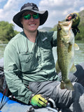
Fishing:
Devils River flourishes when it comes to fishing, packed with smallmouth bass, largemouth bass, catfish, and carp. The usually crystal clear waters make spot casting and sporting fishing one of a kind in Texas. With this type of fishing, there does come some regulation with catch and release that is continuously being updated. The rule of thumb we use is to catch and release all bass, and you can eat anything else. If you want to get technical on bass eating, you can find the Devil's river fishing regulations here.
"As part of the 2017-18 Statewide Recreational and Commercial Fishing Proclamation, the Commission established a catch-and-release only fishing zone for smallmouth and largemouth bass in the Devils River from State Highway 163 Bridge downstream to the confluence of Big Satan Creek Canyon." - Texas Park & Wildlife
Even with the catch and release, there is still plenty of sport fishing to be done! You can even pack out your snorkel, flippers and spear gun for some fun. However, we recommend calling ahead with TPWD to see what fish are restricted for spearfishing.


Fishing Tackle:
According to Austin Rental Boats Owner, Shawn Smith the best tackle setup goes as follows:
Early morning & late evenings tackle- Are a great time for your weedless topwater frogs (black with a white belly). get up close to some Lilly pads or any vegetation and shorelines and start working the frog across. It is pretty amazing watching these bass hit a top water in this clear of water.
- Use a translucent green worm (watermelon). Be sure to setup the worm on a weightless & weedless Wacky rig. Work the worm with a slow double twitch and let it sink it bit for the best results.
- You can also throw a lifelike soft plastic shad or minnow 3".
Devils River Packing/Check List:
- TreadWright Tires for your vehicle to get to Devils River.
- Hyke & Byke 2P Tent
- Inflatable mattress - compact-able only 7 puffs to make and comfortable
- Wag bags (poop bag)
- Whistles
- Inflatable Pillow
- Flashlights
- Sawyer Water Filter
- Knife
- Utility tool
- Two fishing poles
- Fishing tackle
- Cookware
- Wet Wipes - Two to three packs for the restroom and wiping off cooking items.
- Keen Waterproof Shoes (these have great traction)
- Jet boil propane - 2
- Jet boil cooking setup
- Yetti Cooler - You can freeze water bottles the night before and use them as ice and drink them as they melt. Eat solid foods first then move on to backpantry.
- Waterproof lighter/matches
- Environmentally friendly soap
- Two long sleeve dry fits
- Two fishing pants
- Waterproof sleeping bag
- A hydration backpack
- Waterproof first aid kit
- Mosquito Repellant
- Microfiber Towel
- Duct tape
- Snake bite kit
- Utility rope
- Extra battery pack
- GoPro
- Food (breakfast, lunch & dinner * days staying. Bring extra and snacks. Recommend getting backpackers pantry
- Sunscreen
- Camping Lanterns
- Fishing Buff
- Fishing Hat
- Fishing Gloves
- Dry Bags - Recommend the Skog A Kust 70LB bag. They are equipped with a waterproof zipper and are compressible and can fit in the kayak hull. Also, recommend a few small dry bags for easy access.
- Shuttle Rental from Amistad Expeditions ($480 for pick up & drop off)
- Kayak rental from Amistad Expeditions (believe they are $65 a day)
- Portable toilet seat (optional, but nice to have)
- Pop Up privacy tent (optional, but nice to have)
Best Time To Go:
Early Spring to mid summer and early to mid-autumn are generally best. We typically go in early May when the weather is still cool and the river has good water levels from April showers. You can keep track of Devils River water levels here and conduct your own research on typical rain patterns. You must keep in mind even though spring is cool it typically can bring a lot of rain and the river can flood easily from rains 50-100 miles away. At 8FT the river will crest and hopefully by then you have already secured high ground. This is also why we recommend booking out your camp spots with the TPWD incase of an emergency they know where to find you. If you decide to go June - September you can expect very hot temperatures, so be sure to pack accordingly.
Written by Derrest Williams, Jr.